from BeMetals Corp. (NASDAQ:BMTLF)
BeMetals Generates Priority Drill Targets at the Tashiro Gold Project, Kyushu, Japan
VANCOUVER, BC / ACCESSWIRE / April 18, 2023 / BeMetals Corp. (TSXV:BMET), (OTCQB:BMTLF), (Frankfurt:1OI.F) (the "Company" or "BeMetals") is pleased to announce it has integrated recently received drone magnetic survey information with historical drill results that has generated several compelling drill targets at the Tashiro Gold Project ("Tashiro" or the "Project") in Kyushu. These new drill targets focus on testing and potentially extending at least two significant zones of vein-hosted gold mineralization at the Noya and Noya Southwest ("Noya SW") prospects on the Tashiro property.
HIGHLIGHTS OF TASHIRO PROJECT DRILL TARGETS:
Noya Prospect
- Recently completed high-resolution drone magnetic survey both maps and extends target zone at Noya prospect
- Historical results reported from drilling in 1990s indicate a high-grade epithermal gold vein zone
- Gold mineralization target has a strike extent of over 1.5 kilometres, and includes the following selected historical drill intersections:
- 4MAKC-1: 63.90 grams per tonne ("g/t") gold ("Au") & 16.70 g/t silver ("Ag") over 0.47m
- 4MAKC-4: 28.60 g/t Au & 12.90 g/t Ag over 1.08m
- 7MAKN-4: 41.60 g/t Au & 28.40 g/t Ag over 0.30m
Noya SW Prospect
- 9MAKN-7: 1.67 g/t Au & 1.70 g/t Ag over 27.10m, Including: 3.38 g/t Au over 8.95m
- 9MAKN-8: 13.80 g/t Au & 16.70 g/t Ag over 1.30m
Note: Table 1 below provides details of these intersections, and Table 2 the other historical drill intersections within the Tashiro Project
John Wilton, President and CEO of BeMetals stated, "We are delighted with the interpretation of our recently completed airborne drone magnetic survey when combined with the historical drilling data at our Tashiro Project. The Tashiro property is located within the Northern Kyushu epithermal gold province. Importantly, certain features of this new magnetic data are consistent with the orientation of the main Noya prospect gold vein trend. Additionally, signatures in this data indicate the potential extension of this gold vein target zone to some 1.5 kilometres along strike."
Furthermore, on a recent field reconnaissance to the Tashiro Project area, Dr. Richard Sillitoe, world renowned economic geologist, and technical advisor to the Company, noted "Further drill testing of the Noya and Noya SW veins is clearly merited. The historical high-grade vein intersections are at vertical depths of approximately 175 to 200 metres below surface, thereby defining a clear initial depth target for the planned drilling."
John Wilton concluded, "The Company intends to schedule drill testing of the Tashiro Project later in the year after it has completed the current and planned phases of drilling at its Kato and Todoroki projects in Hokkaido, Japan."
TASHIRO GOLD PROJECT
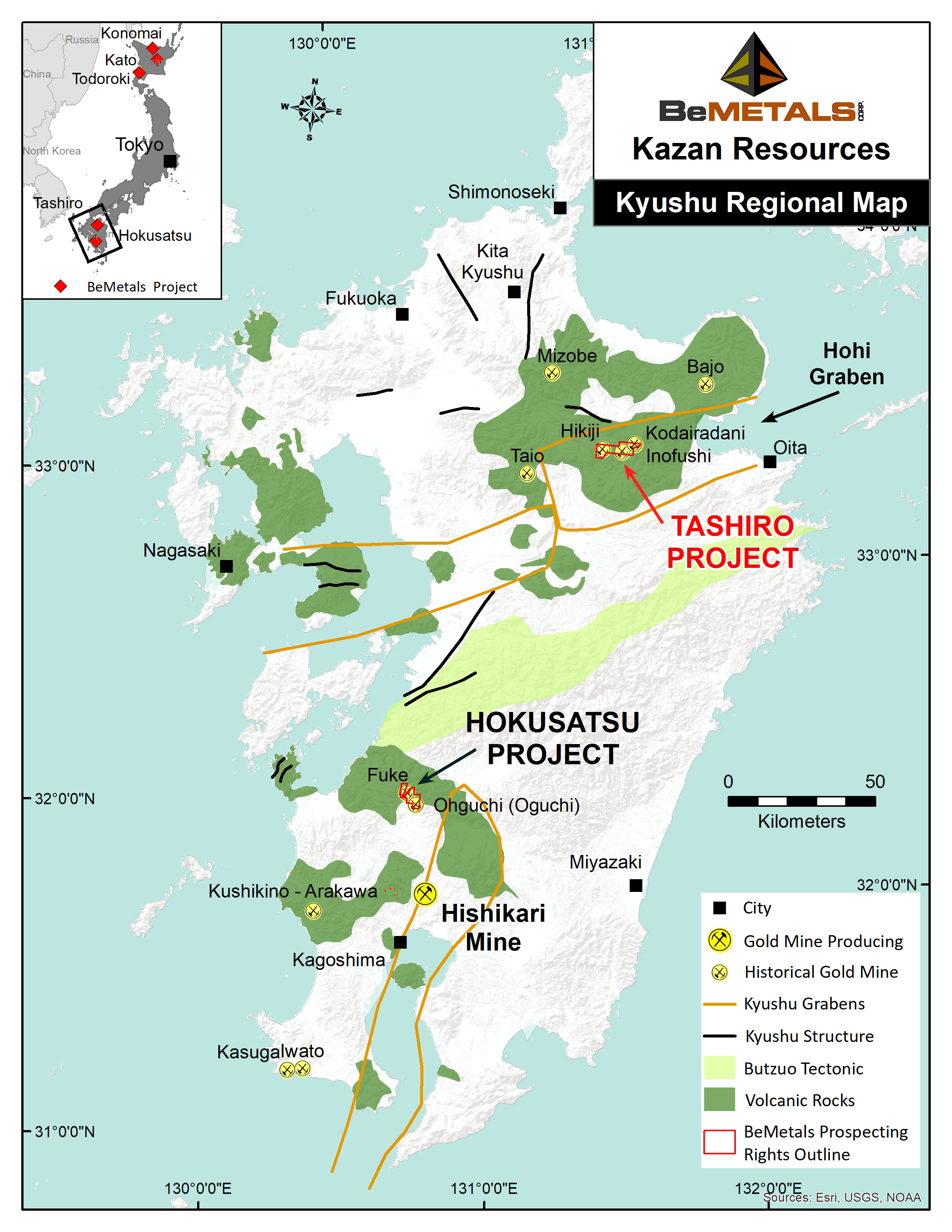
The Tashiro Project is located in Oita Prefecture of central northeastern Kyushu (Figure 1). The Project is situated within the regional scale Hohi Graben, a major geological structure in this district that is associated with numerous historical gold mines and prospects known collectively as the Northern Kyushu epithermal gold province.
Figure 1: Location Map of Tashiro Gold Project, Kyushu, Japan
The high-grade quartz-gold veins of the Noya and Noya SW prospects within the Tashiro Project do not crop out. This area was initially explored for its geothermal energy potential with a single drill hole completed in 1952, and subsequently three more holes were completed in 1977. The existence of epithermal quartz-gold veins in this drill core, with associated intense alteration, was first recognised by Morishita & Takeno and reported in 1989 1 . Motivated by these reported observations and the detection of gold in assays for some of the drilled veins, the Metal Mining Agency of Japan ("MMAJ"), a Japanese state agency, conducted exploration at the Noya and Noya SW prospects (the "Prospects") between 1989 and 1994.
The drilling completed by MMAJ confirmed the development of an extensive epithermal gold system at the Prospects, with many of the hallmarks of such mineralization, such as typical quartz textures and associated trace elements.
Figure 2 below illustrates the location of MMAJ's drill holes and the interpreted approximate east-west strike of the Noya vein zone. This main Noya vein zone trend appears to be mapped by a coincident east-west oriented, magnetic low signature, interpreted to be related to an important controlling structural trend. The Company is intending to complete three to four drillholes to test the Noya and Noya SW prospects.
Figure 2. Drone Magnetic Data with Selected Historical Drill Intersections, Tashiro Gold Project, Kyushu, Japan
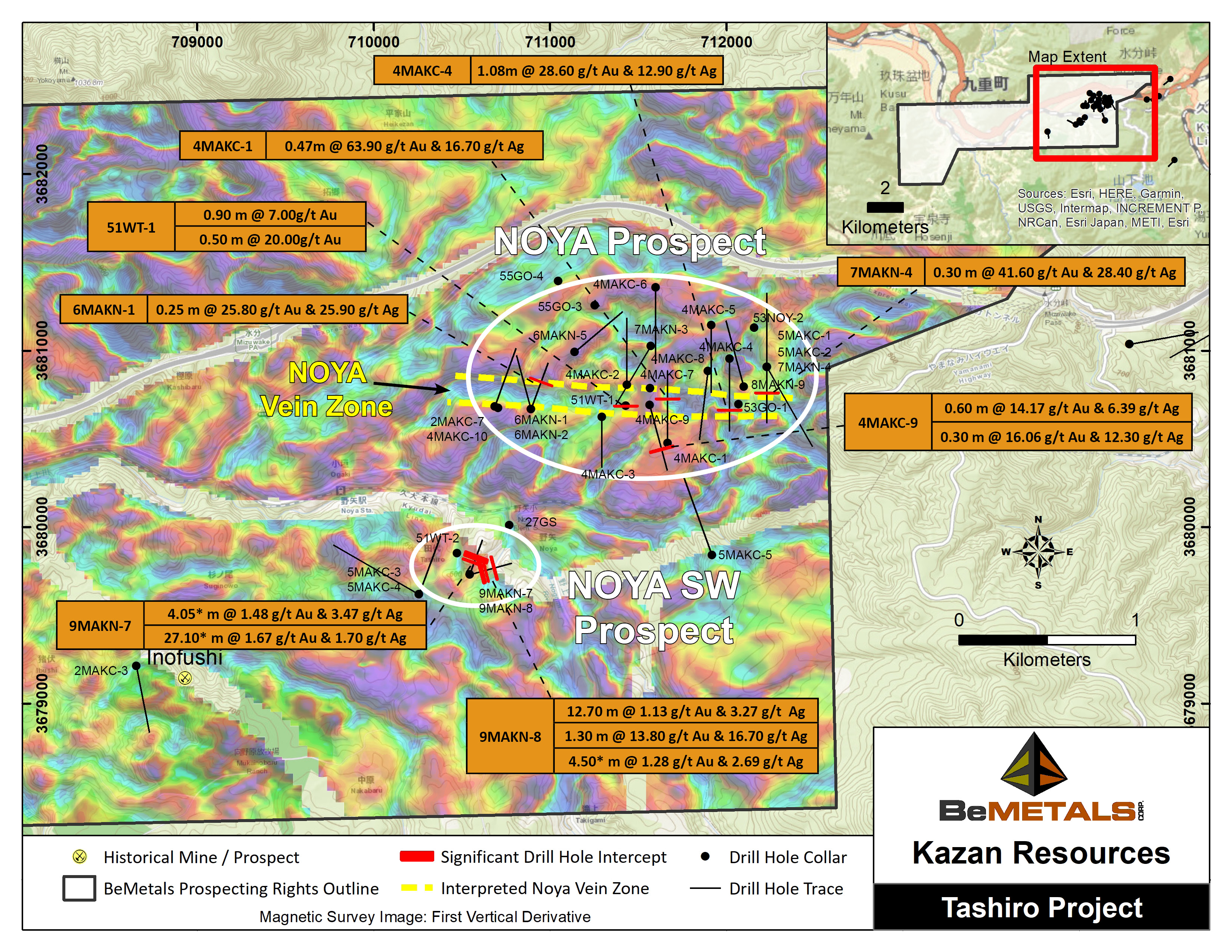
Table 1 below includes the details of the selected MMAJ drill intersections, associated with the main Noya vein zone, and the Noya SW prospects, with drilled widths and gold and silver grades. This series of relatively shallow depth below surface (approximately 175-200m), generally high-grade, gold intersections demonstrate the potential of this epithermal system to generate significant gold grades. This is an encouraging characteristic of these Prospects, motivating the future exploration drilling of the project.
Table 2 provides the gold and silver intersection results of all the remaining historical drill intersections at these two Prospects within the Tashiro Project area. These addition results demonstrate that even outside the initial targets of the main Noya vein zone and Noya SW prospects there is an extensive footprint to the gold mineralization.
Table 3 details of all the historical drill hole locations with; azimuth, dip, end of hole depth and collar coordinate information.
Table 1: Historical Selected Drill Hole Intersection Results
Drill hole and Interval | From | To | Core Interval (m) | Au g/t | Ag g/t |
Noya | |||||
4MAKC-1 | 306.90 | 307.37 | 0.47 | 63.90 | 16.70 |
4MAKC-4 | 353.98 | 355.06 | 1.08 | 28.60 | 12.90 |
4MAKC-9 | 335.55 | 336.15 | 0.60 | 14.17 | 6.39 |
339.55 | 339.85 | 0.30 | 16.06 | 12.30 | |
51WT-1 | 164.20 | 165.10 | 0.90 | 7.00 | NA |
201.00 | 201.50 | 0.50 | 20.00 | NA | |
6MAKN-1 | 234.65 | 234.90 | 0.25 | 25.80 | 25.90 |
7MAKN-4 | 205.80 | 206.10 | 0.30 | 41.60 | 28.40 |
Noya SW | |||||
9MAKN-7 | 90.50 | 95.05 | 4.05* | 1.48 | 3.47 |
121.30 | 148.40 | 27.10* | 1.67 | 1.70 | |
Including: | 121.30 | 127.10 | 5.80 | 1.27 | 1.48 |
Including: | 139.45 | 148.40 | 8.95 | 3.38 | 3.00 |
9MAKN-8 | 84.50 | 97.20 | 12.70* | 1.13 | 3.27 |
119.60 | 120.90 | 1.30 | 13.80 | 16.70 | |
184.40 | 188.90 | 4.50* | 1.28 | 2.69 |
Table 1 Notes: These drill results are historical in nature. BeMetals has not undertaken any independent investigation of the sampling, nor has it independently analyzed the results of the historical exploration work in order to verify the results. BeMetals considers these historical drill results relevant as the Company will use this data as a guide to plan future exploration programs. The Company also considers the data to be reliable for these purposes however, the Company's future exploration work will include verification of the data through drilling. The reported results are drilled intersection widths as the orientation of the mineralized zones and their true thickness is currently not known. Intersections relate to individual samples, except for Noya SW prospect where composites* where calculated using a nominal cut-off grade of 0.5 g/t Au, with a maximum of 2.55 metres of internal dilution, to determine the boundaries of the intersections.
Table 2: Other Historical Drill Hole Intersection Results
Drill hole and Interval | From (m) | To (m) | Core Interval (m) | Au | Ag |
2MAKC-7 | 242.00 | 242.40 | 0.40 | 5.75 | 2.30 |
4MAKC-6 | 320.40 | 320.80 | 0.40 | 4.86 | 11.30 |
4MAKC-10 | 186.95 | 188.35 | 1.40 | 5.04 | 5.84 |
4MAKC-10 | 190.30 | 190.55 | 0.25 | 4.38 | 4.32 |
5MAKC-1 | 396.20 | 396.83 | 0.63 | 3.92 | 1.85 |
5MAKC-2 | 242.20 | 242.67 | 0.47 | 3.43 | 4.36 |
6MAKN-1 | 175.95 | 176.30 | 0.35 | 5.99 | 2.87 |
6MAKN-1 | 180.70 | 180.98 | 0.28 | 8.52 | 9.67 |
8MAKN-5 | 407.45 | 407.90 | 0.45 | 3.59 | 0.82 |
8MAKN-6 | 157.55 | 157.85 | 0.30 | 6.32 | 4.28 |
| Drill holes: 53GO-1,3,4, 53NOY-2 & 27GS were geothermal holes not sampled for gold | |||||
Drill holes: 4MAKC-2,3,5,7,8, 5MAKC-5, 6MAKN-2, 7MAKN-3, 51WT-2, 2MAKC-3,6, & 5MAKC-3,4 were reported as not returning any significant sampled gold mineralization | |||||
Table 2 Notes: These drill results are historical in nature. BeMetals has not undertaken any independent investigation of the sampling, nor has it independently analyzed the results of the historical exploration work in order to verify the results. BeMetals considers these historical drill results relevant as the Company will use this data as a guide to plan future exploration programs. The Company also considers the data to be reliable for these purposes however, the Company's future exploration work will include verification of the data through drilling. The reported results are drilled intersection widths as the orientation of the mineralized zones and their true thickness is currently not known. Intersections relate to individual samples.
Table 3: Historical Drill Hole ID, Azimuth, Dip, End of Hole Depth and Collar Coordinates
Drill Hole ID | Azimuth Degree | Dip Degree | End of hole Depth (m) | Easting (m) | Northing (m) | Elevation |
53GO-1 | 0 | -90 | 700 | 712068 | 3680695 | 620 |
55GO-3 | 0 | -90 | 1085 | 711253 | 3681255 | 670 |
55GO-4 | 0 | -90 | 510 | 711046 | 3681393 | 665 |
53NOY-2 | 0 | -90 | 762 | 712156 | 3681128 | 650 |
2MAKC-7 | 0 | -90 | 600 | 710706 | 3680674 | 650 |
4MAKC-1 | 360 | -35 | 500 | 711666 | 3680474 | 670 |
4MAKC-2 | 360 | -40 | 500 | 711435 | 3680805 | 640 |
4MAKC-3 | 180 | -55 | < |