from Faraday Copper Corp. (isin : CA2176212009)
Faraday Copper Intersects 56.57 Metres at 0.59% Copper at Boomerang and 18.49 m at 0.98% Copper at Banjo
VANCOUVER, BC / ACCESS Newswire / March 19, 2025 / Faraday Copper Corp. ("Faraday" or the "Company") (TSX:FDY)(OTCQX:CPPKF) is pleased to announce the results of seven drill holes from its ongoing Phase III drill program at the Copper Creek Project, located in Arizona ("Copper Creek"). Three holes were drilled in the American Eagle area, three in the Rum area and one in the Horsecamp area.
Paul Harbidge, President and CEO, commented "These results continue to expand the near surface mineralization in the American Eagle area, further validating the potential to define a significant open pit mineral resource in this area and unlock further economic value for the project. Drilling at the Rum and Horsecamp areas confirmed our thesis that these mineral systems are exposed at a shallow level and we see exploration potential at depth. We expect to deliver the updated mineral resource estimate and technical study in the second half of 2025, which will include nearly 40,000 metres of additional drilling from the Phase II and III programs."
Highlights
At the Southern margin of the Banjo breccia, drill hole FCD-24-094 intersected multiple mineralized intervals, providing further confidence in the potential to define a significant open pit mineral resource in the American Eagle area. Drill results include:
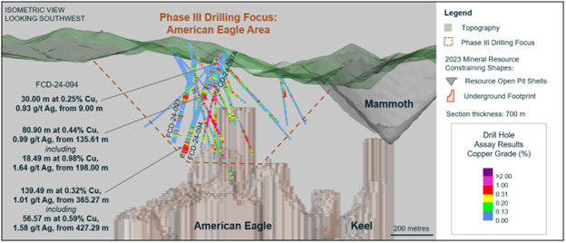
18.49 metres ("m") at 0.98% copper and 1.64 grams per tonne ("g/t") silver from 198.00 m, within 80.90 m at 0.44% copper and 0.99 g/t silver from 135.61 m.
30.00 m at 0.25% copper and 0.93 g/t silver from 9.00 m in porphyry vein-hosted mineralization.
56.57 m at 0.59% copper and 1.58 g/t silver from 427.29 m within 139.49 m at 0.32% copper and 1.01 g/t silver from 365.27 m. This intercept corresponds to the Boomerang breccia and surrounding porphyry vein-hosted mineralization.
At Rum, drill hole FCD-24-095 intersected 19.74 m at 0.83% oxide copper from surface in porphyry and breccia.
(For true width information see Table 1)
The American Eagle area, as mapped on surface, covers approximately 800 m by 1,000 m and is host to numerous prospective breccias and porphyries which have strong copper geochemical signatures (Figures 1 to 3). These surface expressions locate above the large underground porphyry mineral resource1, which is approximately 500 m to 1,100 m depth below surface. Historically, the near-surface mineralization was not adequately tested as previous drilling was vertical to steeply inclined. Mapped geology, isolated historical drill intercepts and historical small-scale mining highlight the potential for near-surface mineralization. The Company has reported assay results for twenty-three drill holes2 from this area as part of the current program. These results provide a broad framework of the geology, structure, and alteration and confirm the potential for significant near-surface copper mineralization. Drilling continues in the area.
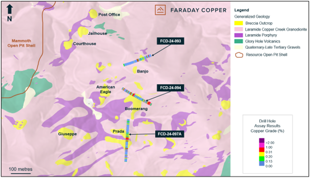
Drill hole FCD-24-094 was collared 100 m northeast of the American Eagle breccia and drilled to the southeast targeting the Boomerang breccia at the southern margin of Banjo. The hole intersected hydrothermal breccia from 155 m to 213 m and from 445 m to 485 m whereas the remainder of the drill hole was granodiorite. Alteration associated with breccia intervals is sericitic whereas kaolinite and sericite are associated with porphyry-style veins outside the breccias. Mineralization occurs as chalcopyrite in breccia cement, disseminated as well as in porphyry-style veins.
Drill hole FCD-24-093 was collared 60 m west of Banjo and drilled to the northeast. It targeted a breccia, which crops out approximately 70 m north of the Banjo breccia. Granodiorite is the dominant lithology to 110 m, followed by igneous cemented breccia with variable hydrothermal overprint to 135 m. A porphyry dyke was intersected from 135 m to 137 m after which the hole entered granodiorite to the end of hole. The alteration associated with the breccia interval is sericite-kaolinite. Chalcopyrite is the dominant copper mineral and occurs together with pyrite in breccia cement and porphyry-style veins.
Drill hole FCD-24-097A was collared 160 m southeast of the American Eagle breccia and drilled to the south, targeting the Prada breccia. The hole starts in igneous cemented breccia for the top 21 m followed by hydrothermal breccia. From 34 m to 113 m the dominant lithology is granodiorite, followed by porphyry to 129 m. From there to the end of the hole hydrothermal breccia is the dominant lithology. Alteration associated with breccia is quartz-sericite with variable amounts of kaolinite and tourmaline. Chalcopyrite occurs together with variable amounts of pyrite forming breccia cement.
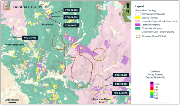
The Rum area is located approximately 700 m northwest of the resource area (Figure 1). It features several breccias and porphyries intruding Glory Hole volcanics over an area of approximately 250 m by 400 m. Copper oxide and secondary sulphide mineralization is observed near surface in breccias and surrounding wall rock.
Drill hole FCD-24-095 was collared in porphyry, approximately 10 m from the Rum breccia contact and drilled to the east. It intersected 14 m of porphyry, followed by hydrothermal breccia to 53 m. The hole enters porphyry thereafter to 114 m, followed by Glory hole volcanics to the end of the hole. The uppermost 53 m of the hole are affected by sericite-kaolinite alteration and oxidation related to weathering, penetrates to approximately 70 m depth. Copper mineralization occurs in the form of malachite, chrysocolla and local chalcocite. Silver values greater than 1 g/t in hydrothermal breccia are observed from 27 m to 53 m.
Drill hole FCD-24-086 was collared northwest of the Rum breccia and drilled to the southeast. It intersected Glory Hole volcanics for the first 150 m followed by hydrothermal breccia to 220 m. The hole then intersected porphyry to 284 m and Glory Hole volcanics until 370 m. Hydrothermal breccia dominates thereafter to the end of the hole. The upper hydrothermal breccia domain is characterized by sericite and lesser-chlorite alteration and abundant pyrite cement whereas the lower domain is kaolinite-sericite altered with pyrite cement.
Drill hole FCD-24-092 was collared west of the Rum South breccia and drilled to the east. It intersected Glory Hole volcanics to 93 m followed by porphyry to 104 m. From 104 m to 214 m breccia dominated with some intervals of porphyry. The hole then enters Glory Hole volcanics to 289 m and granodiorite to the end of the hole. Breccia is associated with sericite and kaolinite alteration and contains pyrite and chlorite in the cement. Elevated silver, together with other pathfinder elements, is observed from 120 m to 214 m, which is suggestive of copper mineralization at depth.
The Horsecamp area is located approximately 2.5 km southwest of the Rum area. Several hydrothermal breccias crop out in the area (Figure 1). These are part of the Western Breccia trend to the west of the resource area. Geology and alteration characteristics of the area suggest that the shallow parts of hydrothermal systems are preserved in the area which suggests exploration potential exists at depth.
Drill hole FCD-24-090 is the first reconnaissance drill hole targeting a breccia zone in the Horsecamp area, approximately 2.5 km southwest of the Rum area. The hole intersected mostly Glory Hole volcanics with narrow porphyry dykes and igneous cemented breccias present between approximately 200 m and 312 m. Intercepts of hydrothermal breccia are present at 360 m to 363 m, 389 m to 392 m, 402 m to 413 m and 436 m to 441 m. Alteration is moderate to locally intense sericite with biotite-potassium feldspar and actinolite present in the lower half of the drill hole. Pyrite occurs throughout the hole but increases with depth. Trace amounts of chalcopyrite have been recorded between 250 m and 310 m. The results from this hole will inform future drill planning in this area.
Next Steps
Phase III drilling commenced in October 2023 and has been focused on near-surface mineralization in new targets, primarily within the American Eagle area.
The Company will have completed nearly 40,000 metres of incremental drilling beyond the current Mineral Resource Estimate ("MRE")1, which represents a significant opportunity to enhance the project value.
Remaining assay results are expected from the American Eagle area and district exploration targets and will be released as they are received, analyzed and confirmed by the Company.
The Company anticipates the release of an updated technical study in the second half of 2025.
Figure 1: Plan View Showing Surface Geology and Location of Drill Holes

Note: The open pit shell is based on constraints used in the MRE as presented in the Copper Creek Technical Report1.
Figure 2: Plan View Showing Surface Geology and Location of Drill Holes in the American Eagle Area

Note: The open pit shell is based on constraints used in the MRE as presented in the Copper Creek Technical Report1.
Figure 3: Isometric View Showing Phase III Drill Holes in the American Eagle Area

Note: The open pit shell and underground footprint are based on constraints used in the MRE as presented in the Copper Creek Technical Report1. For drill holes not reported herein, refer to news releases on the Company's website at www.faradaycopper.com and on the Company's SEDAR+ profile at www.sedarplus.ca.
Table 1: Selected Drill Results
Drill Hole ID | From | To | Length | True Width | Cu | Au | Ag | Mo |
(m) | (m) | (m) | (m) | (%) | (g/t) | (g/t) | (%) | |
FCD-24-093 | 115.23 | 178.08 | 62.85 | 62 | 0.18 | N/A | 0.45 | 0.0006 |
Including | 115.23 | 131.20 | 15.97 | 10 | 0.33 | N/A | 0.69 | 0.0005 |
FCD-24-094 | 9.00 | 39.00 | 30.00 | 30 | 0.25 | N/A | 0.93 | 0.0008 |
and | 135.61 | 216.51 | 80.90 | 30 | 0.44 | N/A | 0.99 | 0.0009 |
Including | 198.00 | 214.49 | 18.49 | 7 | 0.98 | N/A | 1.64 | 0.0005 |
and | 365.27 | 504.96 | 139.49 | 139 | 0.32 | N/A | 1.01 | 0.0007 |
Including | 427.29 | 483.86 | 56.57 | 56 | 0.59 | N/A | 1.58 | 0.0010 |
FCD-24-095 | 0.00 | 19.74 | 19.74 | 19 | 0.83 | N/A | 0.40 | 0.0002 |
FCD-24-097A | 40.45 | 57.12 | 16.67 | 9 | 0.16 | N/A | 0.92 | 0.0010 |
and | 143.30 | 223.81 | 80.51 | 40 | 0.26 | N/A | 0.97 | 0.0007 |
including | 177.22 | 207.31 | 30.09 | 15 | 0.38 | N/A | 1.51 | 0.0009 |
and | 389.29 | 407.55 | 18.26 | 9 | 0.45 | 0.01 | 1.29 | 0.0021 |
FCD-24-086 | No significant results | |||||||
FCD-24-090 | No significant results | |||||||
FCD-24-092 | No significant results | |||||||
Note: All intercepts are reported as downhole drill widths. Mineralization includes bulk porphyry style and breccia mineralization. True widths are approximate due to the irregular shape of mineralized domains. N/A: Not analyzed.
Table 2: Collar Locations from the Drill Holes Reported Herein
Drill Hole ID | Easting | Northing | Elevation | Azimuth | Dip | Target | Depth | Depth |
(m) | (°) | (°) | (ft) | (m) | ||||
FCD-24-093 | 549112 | 3623535 | 1337 | 072 | 50 | Banjo North | 721.9 | 236.83 |
FCD-24-094 | 549100 | 3623423 | 1307 | 120 | 70 | Banjo South and Boomerang | 1539.1 | 504.96 |
FCD-24-095 | 547278 | 3625760 | 1399 | 100 | 45 | Rum | 441.3 | 144.78 |
FCD-24-097A | 549128 | 3623275 | 1295 | 185 | 60 | Prada | 1336.9 | 438.61 |
FCD-24-086 | 547084 | 3625868 | 1386 | 105 | 45 | Rum | 1372.2 | 450.19 |
FCD-24-090 | 546084 | 3625173 | 1294 | 190 | 45 | Horsecamp | 1530.1 | 502.01 |
FCD-24-092 | 547140 | 3625675 | 1414 |

